
How far does a city's influence go?
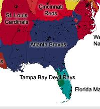
"The CommonCensus Map Project is redrawing the map of the United States based on your voting, to show how the country is organized culturally, as opposed to traditional political boundaries. It shows how the country is divided into 'spheres of influence' between different cities at the national, regional, and local levels."
The website offers a poll and then uses the results to come up with the maps shown here. When I started taking the poll, I didn't know the city well enough to answer the questions. But it is interesting to see how far into the surrouding countryside Atlanta's sphere of influence is shown.
No comments:
Post a Comment